
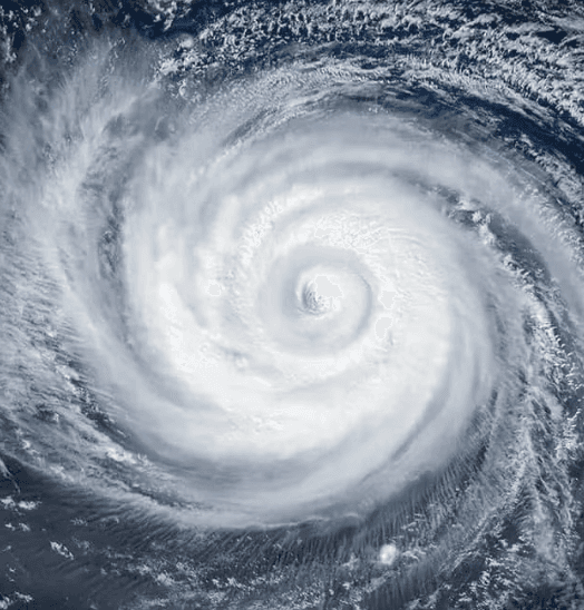
Super Typhoon Dolphin, currently a Category 4-equivalent system with 145 mph sustained winds after peaking at Category 5 intensity, is tracking west-northwest across the western North Pacific toward the Ogasawara Islands. Official Joint Typhoon Warning Center and Japan Meteorological Agency guidance shows it nearing those remote Japanese territories by early August and potentially the seas south of Kyushu or Okinawa by August 6, driven by warm sea-surface temperatures and steering patterns. Ensemble models exhibit notable spread beyond the five-day window, with possibilities of recurvature or weakening that could prevent direct landfall on the main islands. This path uncertainty, combined with the storm’s recent rapid intensification and widening wind field, underpins the market-implied 56.5% probability for a Japan hit.
Tóm tắt AI thử nghiệm tham chiếu dữ liệu Polymarket. Đây không phải tư vấn giao dịch và không ảnh hưởng đến cách thị trường này được giải quyết. · Cập nhậtWill Super Typhoon Dolphin hit Japan?
Will Super Typhoon Dolphin hit Japan?
$16,358 KL.
$16,358 KL.
$16,358 KL.
$16,358 KL.
JMA position advisories are the primary resolution source. If a JMA advisory plots the center on Japanese land, the market resolves "Yes" regardless of what other sources say. If no JMA advisory plots the center on land but credible reporting confirms a crossing occurred between discrete advisory fixes, the market resolves "Yes." A disagreement exists only when a JMA advisory and credible reporting make contradictory claims about the storm's position at the same point in time; in that case, JMA is the default resolution source. In all cases, the classification is taken from the most recently issued JMA advisory prior to the confirmed crossing time.
This is a purely geographic criterion: the storm's center must pass over Japanese land, regardless of whether JMA formally designates the event as "landfall" or "passage." The most recently issued JMA advisory prior to the crossing must classify Dolphin as a tropical cyclone (tropical depression or higher). If that advisory classifies the system as extratropical, dissipated, or absorbed, the crossing does not count and the market will resolve to "No".
This market resolves "No" if Dolphin has been declared extratropical, dissipated, or absorbed on or before August 15 without having made landfall on Japanese territory, or if no landfall has physically occurred by the close of August 15, 2026.
Thị trường mở: Jul 30, 2026, 11:53 AM ET
Resolver
0x65070BE91...JMA position advisories are the primary resolution source. If a JMA advisory plots the center on Japanese land, the market resolves "Yes" regardless of what other sources say. If no JMA advisory plots the center on land but credible reporting confirms a crossing occurred between discrete advisory fixes, the market resolves "Yes." A disagreement exists only when a JMA advisory and credible reporting make contradictory claims about the storm's position at the same point in time; in that case, JMA is the default resolution source. In all cases, the classification is taken from the most recently issued JMA advisory prior to the confirmed crossing time.
This is a purely geographic criterion: the storm's center must pass over Japanese land, regardless of whether JMA formally designates the event as "landfall" or "passage." The most recently issued JMA advisory prior to the crossing must classify Dolphin as a tropical cyclone (tropical depression or higher). If that advisory classifies the system as extratropical, dissipated, or absorbed, the crossing does not count and the market will resolve to "No".
This market resolves "No" if Dolphin has been declared extratropical, dissipated, or absorbed on or before August 15 without having made landfall on Japanese territory, or if no landfall has physically occurred by the close of August 15, 2026.
Resolver
0x65070BE91...Super Typhoon Dolphin, currently a Category 4-equivalent system with 145 mph sustained winds after peaking at Category 5 intensity, is tracking west-northwest across the western North Pacific toward the Ogasawara Islands. Official Joint Typhoon Warning Center and Japan Meteorological Agency guidance shows it nearing those remote Japanese territories by early August and potentially the seas south of Kyushu or Okinawa by August 6, driven by warm sea-surface temperatures and steering patterns. Ensemble models exhibit notable spread beyond the five-day window, with possibilities of recurvature or weakening that could prevent direct landfall on the main islands. This path uncertainty, combined with the storm’s recent rapid intensification and widening wind field, underpins the market-implied 56.5% probability for a Japan hit.
Tóm tắt AI thử nghiệm tham chiếu dữ liệu Polymarket. Đây không phải tư vấn giao dịch và không ảnh hưởng đến cách thị trường này được giải quyết. · Cập nhật
Cẩn thận với liên kết bên ngoài.
Cẩn thận với liên kết bên ngoài.
Câu hỏi thường gặp